数据可视化地图英文为“Data Visualization Map”,它是指通过可视化技术将数据以地图的形式呈现,使用户能够更直观地理解和分析地理信息。 FineReport、FineBI、FineVis是帆软旗下的三款优秀的数据可视化工具,能够实现多种类型的数据展示。其中,FineReport是一款企业级报表工具,支持各种复杂报表和数据图表的生成;FineBI则专注于商业智能分析,提供强大的数据挖掘和分析功能;FineVis则是专为数据可视化设计的工具,能够实现更加丰富和动态的可视化效果。例如,FineReport可以通过简单的配置将数据以热力图的形式展示在地图上,帮助企业快速识别市场热点区域。
一、FINEBI、FINEREPORT、FINEVIS的功能特点
FineBI、FineReport、FineVis分别代表了帆软在不同领域的技术优势。FineBI主要功能包括数据集成、可视化分析、数据挖掘以及数据展示。它提供了丰富的图表类型和灵活的仪表盘设计,使用户能够自由组合和展示数据。FineReport则更偏向于报表设计和生成,它支持多种数据源接入,并提供强大的报表设计器,能够生成复杂的报表和图表。此外,FineReport还支持多种报表格式的导出和打印,满足企业的各种需求。FineVis则专注于数据可视化,它提供了多种动态和交互式的可视化效果,使数据展示更加生动和直观。例如,FineVis的3D地图功能可以让用户从不同角度观察数据,增强数据的可读性和分析性。
二、如何使用FINEBI进行数据可视化地图的创建
使用FineBI创建数据可视化地图非常简单。首先,用户需要将数据导入FineBI系统中,可以通过连接数据库、上传Excel文件等方式进行数据导入。导入数据后,用户可以选择地图组件,将数据字段拖拽到地图上进行展示。FineBI提供了多种地图类型,如热力图、点图、区域图等,用户可以根据需要选择合适的地图类型进行展示。FineBI还提供了丰富的地图样式和配色方案,用户可以根据需要进行自定义设置,使地图展示更加美观和专业。此外,FineBI还支持地图的动态交互功能,用户可以通过点击、缩放、拖拽等操作与地图进行交互,增强数据分析的效果。
三、FINEREPORT在企业报表中的应用
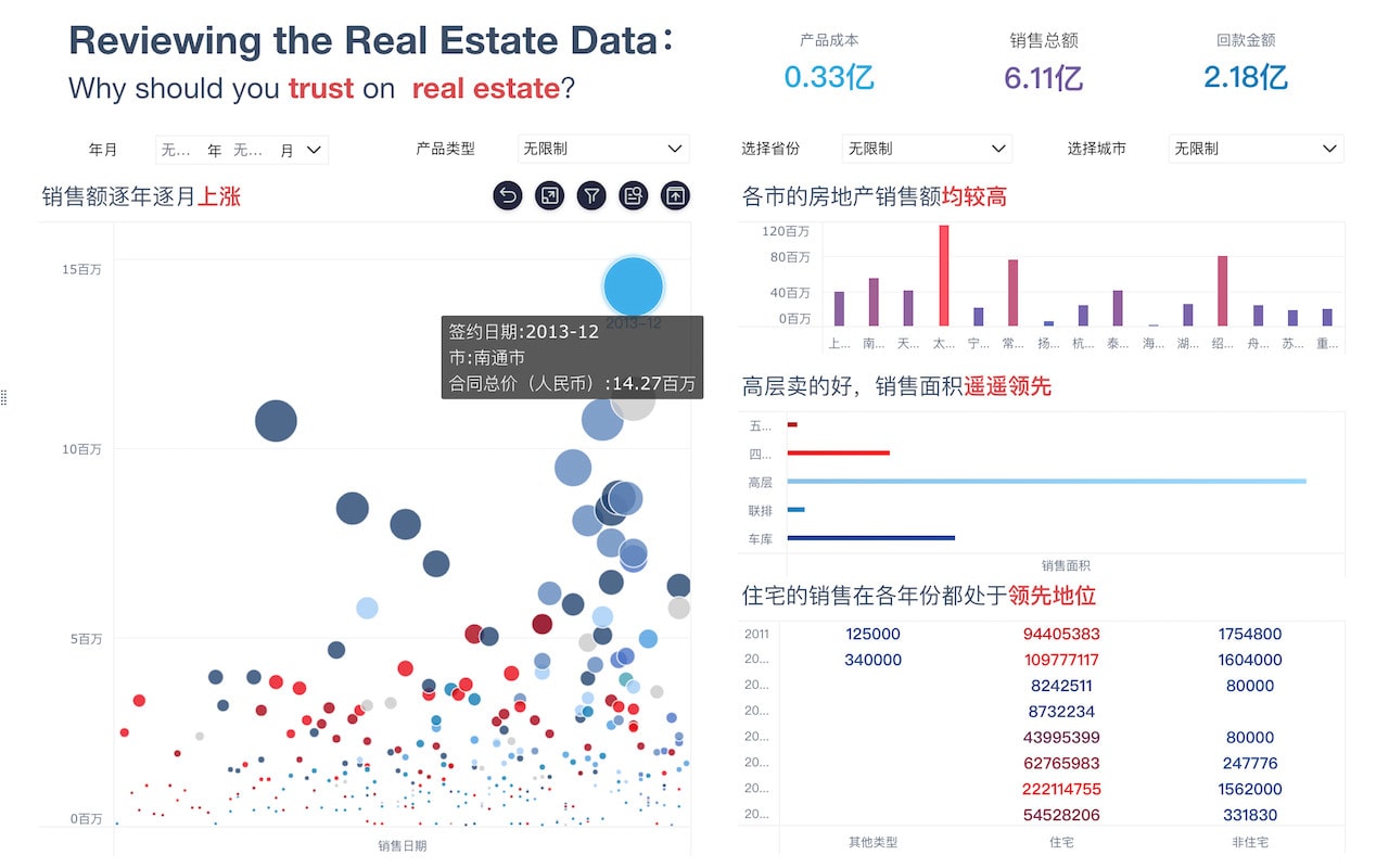
FineReport在企业报表中的应用非常广泛,它支持多种数据源接入,如数据库、Excel文件、Web服务等,能够满足企业的各种数据需求。FineReport提供了强大的报表设计器,用户可以通过拖拽组件的方式轻松设计报表,包括表格、图表、图片、文字等元素。此外,FineReport还支持多种报表格式的导出和打印,如PDF、Excel、Word等,方便企业进行数据分享和归档。FineReport还提供了丰富的报表模板,用户可以根据需要选择合适的模板进行快速报表设计。例如,企业可以使用FineReport设计销售报表,通过热力图展示各区域的销售情况,帮助企业快速识别市场热点区域,制定有效的销售策略。
四、FINEVIS在数据可视化中的独特优势
FineVis在数据可视化中具有独特的优势。首先,FineVis提供了多种动态和交互式的可视化效果,如3D地图、动态气泡图、交互式柱状图等,使数据展示更加生动和直观。其次,FineVis支持多种数据源接入,用户可以通过连接数据库、上传文件等方式导入数据,方便快捷。此外,FineVis提供了丰富的可视化组件和样式,用户可以根据需要进行自定义设置,使数据展示更加美观和专业。例如,FineVis的3D地图功能可以让用户从不同角度观察数据,增强数据的可读性和分析性。FineVis还支持数据的动态更新,用户可以实时查看最新数据,提升数据分析的效果。
五、数据可视化地图在实际应用中的案例分析
数据可视化地图在实际应用中具有广泛的应用场景。首先,在市场分析中,企业可以通过数据可视化地图展示各区域的市场销售情况,帮助企业快速识别市场热点区域,制定有效的销售策略。其次,在物流管理中,企业可以通过数据可视化地图展示物流运输线路和节点,帮助企业优化物流路线,提升物流效率。此外,在公共服务领域,政府部门可以通过数据可视化地图展示各区域的公共服务设施和资源分布情况,帮助政府制定合理的公共服务规划,提升公共服务水平。例如,某市政府通过FineReport设计了一份公共服务设施分布图,通过热力图展示各区域的医院、学校、图书馆等公共服务设施的分布情况,帮助政府制定合理的公共服务规划,提升公共服务水平。
六、数据可视化地图的发展趋势和未来展望
数据可视化地图的发展趋势和未来展望主要体现在以下几个方面。首先,随着大数据技术的发展,数据可视化地图将越来越多地应用于大数据分析中,通过可视化技术将海量数据以地图的形式展示,帮助用户快速理解和分析数据。其次,随着人工智能技术的发展,数据可视化地图将更加智能化,通过机器学习算法自动识别数据中的模式和趋势,提升数据分析的准确性和效率。此外,随着虚拟现实和增强现实技术的发展,数据可视化地图将更加立体化和沉浸式,通过3D地图和虚拟现实技术,用户可以更加直观地观察和分析数据。例如,FineVis的3D地图功能可以让用户从不同角度观察数据,增强数据的可读性和分析性。未来,数据可视化地图将在更多领域中发挥重要作用,帮助用户更好地理解和利用数据。
FineBI官网: https://s.fanruan.com/f459r
FineReport官网: https://s.fanruan.com/ryhzq
FineVis官网: https://s.fanruan.com/7z296
相关问答FAQs:
How do you say "数据可视化地图" in English?
The English translation for "数据可视化地图" is "data visualization map." Data visualization refers to the graphical representation of data to provide insights and facilitate understanding. A data visualization map, therefore, is a visual representation of data on a map, which can help users to analyze and comprehend geographical information more effectively.
What are the benefits of using data visualization maps?
Data visualization maps offer several benefits, including:
-
Improved understanding: By presenting data in a visual format, data visualization maps make it easier for users to comprehend complex information, patterns, and relationships.
-
Enhanced decision-making: Visualizing data on a map allows for better decision-making by providing a clear and comprehensive view of geographical data, which is particularly useful for businesses, governments, and researchers.
-
Communication of insights: Data visualization maps are effective tools for communicating insights and trends to a wide audience, as they can convey information in a more engaging and accessible manner.
-
Identification of spatial patterns: Mapping data can reveal spatial patterns and trends that may not be apparent in tabular or textual formats, thus aiding in spatial analysis and planning.
What are some common types of data visualization maps?
There are various types of data visualization maps, each suitable for different purposes. Some common types include:
-
Choropleth maps: These maps use color gradients or patterns to represent statistical data for geographic areas, such as countries, states, or counties. Choropleth maps are effective for visualizing population density, income levels, and other statistical measures.
-
Dot distribution maps: Dot distribution maps use dots or symbols to represent the quantity or density of a specific phenomenon in different locations. This type of map is useful for displaying the distribution of points of interest, such as crime incidents or disease outbreaks.
-
Heat maps: Heat maps visualize data density by using color gradients to indicate areas with higher or lower concentrations of a particular variable. They are commonly used to display levels of activity, such as website traffic or real estate prices.
-
Proportional symbol maps: In proportional symbol maps, the size of symbols or icons on the map corresponds to the magnitude of the data being represented. This type of map is effective for displaying point-specific data, such as the magnitude of earthquakes or the volume of sales in different locations.
-
Flow maps: Flow maps show the movement of objects, people, or information between different locations. They are valuable for visualizing migration patterns, trade routes, and transportation networks.
In conclusion, data visualization maps play a crucial role in making complex data more understandable and actionable. Whether it's for business analysis, urban planning, or scientific research, the visual representation of data on maps can provide valuable insights and facilitate informed decision-making.
本文内容通过AI工具匹配关键字智能整合而成,仅供参考,帆软不对内容的真实、准确或完整作任何形式的承诺。具体产品功能请以帆软官方帮助文档为准,或联系您的对接销售进行咨询。如有其他问题,您可以通过联系blog@fanruan.com进行反馈,帆软收到您的反馈后将及时答复和处理。